Stonehenge
A group of stones whose layout continues to be a mystery
Come along on a journey of moving big heavy stones around the country just to make a pretty design.
Part 1
Before the Stones
We start our journey way back in the Mesolithic Period and as we look around and take in our surroundings we see that there appears to be a fair bit of land covered in woods, especially down here in Southern England. But then there’s this odd open space and it’s this open space that in the current times, while the surrounds are definitely different, sits Stonehenge. Perhaps this is why Stonehenge is placed where it is, it was just a conveniently empty space.
The earliest structures that are believed to have stood in the area are thought to have been large pine posts that may have had a striking resemblance to the totem poles you see in Native American cultures. They’re believed to have popped up in this Mesolithic Period, or roughly between 8500 and 7000 BC.
Even though these posts appeared in the same area where Stonehenge sits today it isn’t really known if these totem-like poles had anything to do with Stonehenge. So there’s your first mystery for you.
Both the Mesolithic and Neolithic periods were dominated by hunter-gatherer groups. It’s really weird to see hunter-gatherers building monuments so grand as Stonehenge, they certainly didn’t have the technology to make it anything resembling easy. And it seems they were alone in their decision to create the structure as you won’t see anything like it anywhere else in north-western Europe.
And yet the area surrounding Stonehenge is pretty pumped full of evidence of massive hunter-gatherer activity throughout the Neolithic Period. You don’t even have to go 5 km from Stonehenge before you find barrows, which are Neolithic burial mounds, and cursus’, Neolithic ditches or trenches.
Right at the beginning of the Neolithic Period, so we’re now looking about 1500 years before Stonehenge, it’s believed that people started filtering in from Continental Europe. And the first domesticated plants and animals appear to have come with them.
And it’s these early people that seemed to have brought the ideas of building and making objects and monuments. This can be seen in how styles and ideas were shared across the British Isles, interestingly in the evidence left to us it seems that each region had their own distinctive style. The carved stone balls found throughout north-east Scotland is an example of this. Hundreds of them have popped up and believed to have been prevalent around 3100 and 2600 BC. While we really don’t know why they were made, they’re an interesting find for the area and the time period.
Much like our understanding of the purpose of Stonehenge, as well as the people who put the thing together, we don’t really have any idea why they would have dragged massive stones over decent distances without any modern invention.
A Henge of Stones
Stonehenge is an engineering marvel. Built before the invention of the wheel, or even before any metal tools to make the process easier, the stones were shaped and brought to their current position using basic and simplistic tools.
And it wasn’t just Stonehenge, all over the Salisbury Plain you’ll find evidence of occupation throughout these early periods. In fact, between 2200 and 1700 BC, which is part of the Bronze Age, you’ll find over 1000 barrows (or ancient burial mounds) along the River Avon from Stonehenge all the way up to Durrington.
The henge itself was built in several stages, we’ll get to the particulars of that in a moment, but for now we’ll just look at the basic strokes.
Initially there was a henge monument little is known about this but part of the stone circle that we see today was added throughout the late Neolithic period or around 2500 BC.
It’s believed that these people who made this early Stonehenge would have used deer antlers to have dug the circular ditch on the Plain.
As well as stones a ring of holes has also been discovered, called the Aubrey Holes after the 17th century antiquarian, John Aubrey, who found the holes and realised they were in a ring. Since then archaeologists and historians have come to the conclusion that timber posts would have sat in these holes. So perhaps not STONEhenge, but MIXEDhenge? But this school of thought is constantly changing, the truth is that no one really knows what would have sat in these holes.
It’s also thought that the burial mounds that you see nearby would have popped up in the early Bronze Age. And it’s not just burial mounds, there are evidence of buried cremations. Which does give rise to the theory that Stonehenge was a Neolithic cemetery.
So of the stones that appear at Stonehenge there are two distinct types. The larger stones are known as ‘sarsens’ and the smaller ones are named ‘bluestones’.
You’ll find the sarsens in two concentric circles, the inner one is a horseshoe shape and the outer one a circle. The bluestones are in between the two sarsens circles and are in a double arc.
It’s thought that the sarsens were brought over to the Salisbury Plain from West Woods near Marlborough Downs, about 25 km north of Stonehenge. That’s a fair way to drag a stone for an art installation, especially when the stones weigh about 25 tonnes and that’s just the small ones the largest stone at Stonehenge, known as the Heel Stone, weighs about 30 tonnes.
On four of the sarsen stones archaeologists found they were carved with hundreds of images of axe-heads and daggers. They look to be similar to bronze axes that supposedly date to between about 1750 and 1500, so not too long after the henge was built perhaps while things were still being tweaked. The images are thought to maybe be a status symbol in the societies living in the early Bronze Age, but much like everything to do with Stonehenge a definitive answer is ever elusive.
Some of the sarsens have a lintel sitting atop, and these structures are known as trilithons, and can be seen upright at the centre of Stonehenge.
While there are only 50 sarsen stones that you can see when you visit the henge yourself, it’s believed that back in its heyday there would have been way more, but yet again that exact figure is not exactly known.
It's believed that Stonehenge was being tweaked and stones moved around until about 1600 BC, the reason we know this is because radiocarbon dating of the bluestones has been carried out multiple times.
The bluestones are the smaller stones that you see. It’s believed that these guys came from Preseli Hills in the south-west of Wales, that’s over 250 km from Wales to Stonehenge. Clearly these stones must have held some importance to the Neolithic people, surely if they were carried all that way.
One theory is that the people who built Stonehenge may have used tree trunks to roll the stones from the Preseli Hills all the way over to Salisbury. Another interesting theory is that they used rafts to float the stones down along the coast and then up the River Avon, which actually seems like a pretty ingenious idea. Work smarter, not harder.
The name of ‘bluestones’ might be a bit strange to some of us because the stones aren’t necessarily blue in colour. That bluish appearance does appear however when the stone gets wet or when the stones are freshly broken, so if you want to see the colours try and get there on a typically drizzly English day.
The stones are a fair bit lighter than the sarsen stones, about 2 to 5 tonnes for each of them. Which does make sense as it’s believed that originally 80 bluestones would have sat at Stonehenge but you can only see just over half of them if you visit today.
Here’s Andrew Fitzpatrick from Wessex Archaeology to tell us what the movement of the stones meant:
Their arrival is when Stonehenge was transformed from a quite ordinary and typical monument into something unusual.
Roughly 300 years later the bluestones were moved around so that they formed a circle and then a smaller inner oval. But this wouldn’t be their final arrangement, later down the track they would be moved again this time to form an outer circle and an inner horseshoe which coincidentally is the formation you see today.
It’s also around this time of stone rearrangement that it’s thought that the avenue that connects Stonehenge with the River Avon was formed.
An interesting discovery was that of the Y and Z holes, antler remains found within them have been radiocarbon dated to around 1800 and 1500 BC which means that these holes could have been the last prehistoric activity to have taken place at Stonehenge. Like so much else to do with the stones their purpose is not known, but it is thought that it may have been the start of a new layout for the stones that was cut short and never completed.
In order to get all the stones sitting nicely and the lintels to not fall off a system of mortice holes and tenons was used. Once the stones were erected and upright using wooden stakes and A-frames they were then able to, supposedly, use timber platforms to raise the lintels into position. On the top of the upright stones the top of the stone would have been shaved down except for a bump, this bump would then have a corresponding ‘hole’ in the bottom of the lintel. This protruding tenon would sit in the mortice hole of the lintel ensuring the lintel wouldn’t move. The amount of precise measurements here from a prehistoric peoples is just astounding. And for some double protection, lintels next to each other would be held fast by tongue and groove joints. This is particularly interesting because you usually don’t see this kind of joint outside of woodworking.
For some cool images of the way the stones are slotted together check out this link.
It’s believed that in the early Bronze Age a majority of the barrows found around Stonehenge were built and it looks as if the chosen location was on purpose. This has led credence to the theory that Stonehenge has something to do with burials.
But as we move into the Middle Bronze Age we start to see less and less monuments, like that of Stonehenge, constructed and more focus on farming and fields.
It seems that during the Roman period, so from about 43 AD, that Stonehenge would have been a spot visited by Romans mainly due to the amount of Roman objects found in around the henge. But recent excavations have raised the theory that perhaps Stonehenge was used as a place of ritual for the Roman people as well.
It’s actually from the medieval period that we see the first written records of Stonehenge. These early references are thought to be the earliest surviving ones about the Stones and the number of mentions only increase as we move further away from the 14th century, they even threw in some drawings and paintings just to keep things interesting.
Building the Henge
So archaeologists and historians now know that Stonehenge was probably being worked on and perfected for close to 400 years.
Unfortunately little is known about Stonehenge throughout the early years mainly because our own early excavations weren’t exactly the best. Here’s Mike Pitts to tell us a bit more about it, he’s the editor of British Archaeology and has actually led an excavation at Stonehenge himself which is a rare thing these days.
But none of these [early] excavations were particularly well recorded. We are still unsure of the detail of the chronology and nature of the various structure that once stood on the site.
Anyway, what we do know is that Stonehenge was made in stages, we think about six, so let’s get stuck into them.
The first stage of Stonehenge is thought to have been built between 3000 and 2935 BC. This is the oldest part of the henge and was basically just a circular ditch measuring about 100 metres across. Found within the circle where about 56 holes, they would later be known as Aubrey Holes. These were named after the bloke that figured out what they were in 1666, John Aubrey.
It’s thought that those who built this circular ditch used antlers as prehistoric picks to dig the ditch, this is evidenced by the pieces of antler found at the bottom of the ditch during an excavation. It was also found that cattle and deer bones that seemed to already have been a couple hundred years old were placed in the ditch as well.
As previously mentioned, the theory behind what the Aubrey Holes purpose was has changed over the years. Initially it was thought that the holes held wooden posts, but excavation and research carried out by the Stonehenge Riverside Project found that it’s more likely the holes held bluestones whose origin would have been Wales.
It really is a definite possibility that Stonehenge had a part to play in burial and the fact that about 150-240 cremation sites were found within and around the circular ditch and Aubrey Holes does only add to the likelihood of this possibility.
Of the cremation burials about 64 were excavated in the first decade of the 21st century and of these excavated burials most of them were adult males, so the archaeologists came to the conclusion that the area around the Aubrey Holes was originally used as a place of burial, probably between 3000 and 2300 BC. Oddly enough Stonehenge is actually the largest cemetery known in Britain that dates back to the 3rd millennium BC.
The remains of a smaller stone circle made of bluestones and creatively known as Bluestonehenge was found by the Stonehenge Riverside Project in 2009 about 1.6km away on the bank of the River Avon. It’s believed Blustonehenge was made up of 25 bluestones and was possibly used as a place for cremation before the remains were scattered at Stonehenge. Sadly Bluestonehenge no longer exists, it’s actually believed that the stones that made up Bluestonehenge were later relocated to Stonehenege itself.
It’s believed that these bluestones came all the way from southwest Wales, or more precisely the Preseli Mountains. It’s also thought that the Altar Stone along with another two sandstone uprights came from the Brecon Beacon’s, which is a group of mountains that can be found about 100 km east of the Preseli ones.
The Altar stone is an interesting one, it isn’t actually an altar at all. It only got that name because Inigo Jones, a 17th century architect (not to be mistaken with Indiana Jones, the fictional archaeologist), thought that the toppled stone that just happened to land in the centre of the circle looked like an altar.
Even though the consensus is that these stones were dragged all the way from Wales to Salisbury, there are some geologists that argue the point that the stones may have already been sitting, very conveniently, in the Salisbury Plain brought there by glaciers throughout the ice-age. But there is some contention about this theory. It’s just so convenient.
The Heelstone, quite a large sarsen, is also believed to have been put in at this first stage of construction, actually there are some that believe it may have been there even before this first stage.
Now except for some burials continuing, the people must have been pretty chuffed with their construction efforts because there doesn’t appear to be any activity taking place between the first and second stages in Stonehenge’s construction. So basically between 2935 and 2640 the place was used as is.
The second stage of construction is thought to have been between 2640 and 2480 BC. It was actually around 2500 BC that the majority of the sarsen stones would have been brought down from Marlborough Downs.
It’s thought that the stones were first placed northeast of the henge where they were made smooth by the use of hammer stones then, when they were ready, they would be taken into the circle and placed in the appropriate spot. The initial formation of the sarsen stones would have been five trilithons (which are two upright stones with a lintel sitting on top) in a horseshoe shape, the largest trilithon would have sat in the middle, and there would have been 30 upright sarsens forming a circle each with their lintels slightly curved, to take into account the curvature of the circle, and linked together with that tongue and groove joint we talked about earlier.
Most of the sarsens put in are about 5.5 metres high and weigh about 25 tonnes, but the massive trilithon, the one found in the centre, was about 9 to 10 metres high and weighed about 45 tonnes. We only have an estimate for this as there’s only one of the uprights remaining and it currently measures about 7 metres tall. Even sadder is that only 6 out of, what’s thought to be, around 230 lintels are still in their original spots in the sarsen circle and there are two more that have fallen, but of the five sarsen trilithons three are still in their spot with the remaining two on the ground as well.
The incomplete sarsen circle does lend itself to some theories about what might have happened. Of course the circle may have just never been completed. But because there is an empty hole it does suggest that perhaps this stone was used by the Romans for one of their buildings nearby.
The bluestones are believed to have originally been in a double arc, Richard Atkinson, who took part in excavations in the 50s and 60s, named these holes the Q and R holes. According to Atkinson, the Q and R Holes were around before the sarsen stones and trilithons were brought in, but when Darvill and Wainwright came along and excavated in 2008 they weren’t too sure about this. (We’ll talk more about these guys in part two). It’s thought that these bluestones were reused from Bluestonehenge and that the arc they formed were meant to be a part of the sarsen circle and trilithons.
The bluestones themselves are pretty small at 2 metres tall compared to the sarsens and oddly enough most of them are their natural shape as opposed to the worked smooth sarsens.
The Station Stones which are four upright stones that stand near the Aubrey holes are thought to have been added during this second stage of construction, but there are some that think they may have been added in between the first and second stages. The stones were put in a rectangle that was inline with the great trilithon and the bluestone arc, which conveniently (or not) was also aligned with the solstitial axis. Unfortunately, only two of the four have survived the many centuries that have passed.
Presumably around the same time as the sarsens were going up about 3 km away two concentric timber circles were being built. The larger of these is known as the Southern Circle and could be found in the middle of an ancient settlement. The smaller of the two is known as the Northern Circle and was built just north of the ancient settlement.
This ancient settlement is thought to have been made up of about 1000 houses and spread across 17 hectares after an excavation of nine of the houses took place between 2004 and 2007. It’s believed that the settlement was used as a seasonal builders’ camp for all the stones and timber posts that were being up-righted in the immediate area. Interestingly just outside the settlement stood the third timber circle in the area, known as Woodhenge for obvious reasons.
The third stage of the Stonehenge construction appears to have taken place between 2470 and 2280 BC. It was sometime throughout this period that the ceremonial avenue that links Stonehenge to the River Avon was dug. It’s thought that the avenue was along the same path that the bluestones would have gone along when they were moved from Bluestonehenge to the Q and R Holes that appeared during the second stage.
The avenue isn’t uniform in its width varying from about 18 to 35 metres and the avenue ends at a small henge close to the river. Oddly enough the first 500 metres closest to Stonehenge are aligned with the summer solstice sunrise and the sunset of the winter solstice. Amazingly excavations that took place in 2008 showed that these 500 metres were built along a natural chalk ridge that just happened to be aligned to the solstices.
The fourth stage of construction was between 2280 and 2030 BC, but it was around 2200 BC that the bluestones were moved around so that they formed a circle and an inner oval. Our mate Atkinson had the thought that the inner oval was changed to form a horseshoe by Romans removing the stones or someone later on taking one of the stones for themselves.
Stonehenge’s fifth construction stage occurred between 2030 and 1750 BC, it was also somewhere in here that the Z Holes were dug. This ring of pits was found outside the Sarsen circle.
A similar thing happened throughout the sixth construction stage, which is thought to have been between 1640 and 1520 BC, the Y Holes, a second ring of pits, was dug. Unfortunately because of the large estimation ranges with radiocarbon dating pretty much all of the dates can be out by several decades, sometimes even centuries, so take any dating around Stonehenge with a couple of grains of salt.
Excavations of the Stones
The earliest known excavation to have taken place at Stonehenge was, supposedly, to have been in the very centre of the stone circles. It was George Villiers, the first Duke of Buckingham, who was out looking for treasure in the 1620s and must have thought that a group of stones could very easily be a substitute for an ‘X’.
The intrigue that Villiers brought with him to the stones had James I, who was King at the time, thinking something could be important here, so he got our old friend Inigo Jones, the architect, to come round and have a good look into the stones. Eventually coming to the conclusion that Stonehenge had to have been built by the Romans, and why not, most things were.
Old mate John Aubrey stopped by in the late 17th century and started surveying the stones, this was where he first recorded the ring of pits that would later bear his name, the Aubrey Holes. But Aubrey wasn’t all about the holes in the ground, his is actually the first known drawing of Stonehenge to be of any accuracy which he produced in 1666.
But Aubrey didn’t limit himself to just Stonehenge, he went all over Britain studying and surveying all the other circles he came across, namely Avebury, and pretty much came to the conclusion that it couldn’t have been the Romans or even the Danes that had built the Stone circle, it had to have been even earlier, it had to have been the native inhabitants of the land, and that meant Druids. Why Druids? Probably because back in the day they were the only prehistoric people that priests had thought worthy enough to mention in their classical writings. So Druids it was.
Aubrey’s conclusion about the Druids was backed up by another antiquarian, William Stukeley, who popped round to survey Stonehenge in the 18th century, he was actually the first one to recognise and record the Avenue and the Cursus that sits nearby.
It was also Stukeley who first used the term ‘trilithon’ when talking about two upright stones and a lintel sitting on top. And he was serious about studying Stonehenge, reportedly, in 1723 he spent over two days just measuring the stones, ending up with over 2000 measurements.
By using units of measurement he was able to disprove that Stonehenge was built by the Romans, because the Roman units of measurement weren’t used when placing the stones. When using the Roman units of measurement
the distance between the stones produced fractions of numbers.
The fact that the distances between stones weren’t whole numbers according to the Romans, Stukeley decided was
ridiculous and without design.
So Stukeley came to the same conclusion as Aubrey: the stones had to have been made before the Romans, by the ancient inhabitants of the land, and that meant more Druids.
Once we get round to 1874 Sir William Flinders Petrie had turned up to survey Stonehenge for himself. Coming back to do it again in 1877 allowed him to devise a numbering system for each of the stones that we actually still use today. Known more for his work in Egypt, Flinders Petrie was able to draw the most accurate image of Stonehenge.
In the late 19th century one of the sarsen stones and, consequently, its lintel fell and this prompted concerns about the stability of the stones. And so in 1901 we see some of the stones, particularly the large trilithon that was leaning at the time, straightened to preserve their positions. Professor William Gowland took advantage of the straightening work going on to conduct some excavations around the base of the leaning stones. By using excavation techniques he brought with him from Japan, and piecing together what he found, Gowland was able to put forward the theory that the stones were built in the late Neolithic or early Bronze Age.
Not too long later in 1918 Stonehenge’s ownership changed from a private owner to that of the Office of Works, we will go into more detail about this in part 2 but this change in ownership meant that a survey was conducted that deemed a couple of stones as unsafe and therefore a full-on programme of restoration and excavation was needed.
Enter Lieutenant-Colonel William Hawley, originally a military man he found his passion in archaeology and was asked to oversee the programme at Stonehenge in 1919. After first concentrating on straightening the most dangerous of the stones, Hawley soon started to focus on the excavation part of the programme in 1920, which included
[excavating] the whole of Stonehenge within and including the circular ditch and bank.
Even though Hawley’s excavations were cut short he managed to get a surprising amount done. Recently his work has faced some criticism but he was a meticulous observer and compared to the standards and methods of the time he did a pretty decent job. In fact it was actually Hawley who named the pits, first noted by John Aubrey, the Aubrey Holes. And it was in fact Hawley who thought they had originally held bluestones but he, himself, changed his mind when he saw that Woodhenge was made of timber posts. But as we know current thinking is that the Aubrey Holes did in fact hold stones after all. It was also during Hawley’s time that the Y and Z holes were uncovered.
Hawley was out there excavating for a good seven seasons, much of the time by himself but he didn’t let that stop him from jotting down his thoughts and theories on the reasons for the stones. But his theories were incomplete due to the limited knowledge of the Neolithic and Bronze Age inhabitants of the land. Knowledge in this area really only started to grow as Hawley was finishing up his work at Stonehenge.
Aerial photography of the whole place was taken in 1925 and 1926 and it showed dark spots near the henge known as Durrington Walls. It was the Wiltshire archaeologist, Maud Cunnington, who, along with her husband and a small team, went about excavating the site where the dark spots were found. This site, mainly because of its similarities to Stonehenge, was called Woodhenge. Cunnington published the results of her excavations and even created a presentation for visitors by marking where the timber posts would have stood with concrete pillars.
Around 1950 Richard Atkinson, Stuart Piggott and JFS ‘Marcus’ Stone turned up to have a look at excavating Stonehenge themselves and they hung around until 1964. They really wanted to answer some questions that had been left open by Hawley as well as take part in restabilising the stones.
The Society of Antiquaries asked Atkinson if he could have a look at the records left unpublished by Hawley in 1950 and see if he could work them into a publishable volume. In order to do this, the three blokes decided that some extra limited excavations would be needed if they were going to attempt to answer those unanswered questions. So they went ahead and closely looked at two of the Aubrey Holes, the Heel Stone, part of the Avenue, part of the bank and ditch and a selection of bluestones.
Even though he was an active professor, first at the University of Edinburgh and later at Cardiff University, Atkinson was quite involved with the restoration project that took place between 1958 and 1964, which actually uncovered a double bluestone arc.
Atkinson went ahead and wrote a book on his theories about Stonehenge, mainly his ‘three-stage chronology’ for the site. He was also pretty popular doing TV and radio guest spots, but oddly enough he never fulfilled his originally purpose of formally publishing his and Hawley’s left-over research. It wasn’t actually until 1995 that an archaeological report on the excavations was officially published by Wessex Archaeology.
The report showed the chronological development of Stonehenge and it was Alex Baylis, who was an expert on radiocarbon dating, who went down to Salisbury to use new techniques to figure out just what was the chronology. It is Baylis’ research that allows us to understand the phases of which Stonehenge was built as well as the changes that would have taken place in the surrounding landscape towards the end of the 3rd millennium BC.
It was also around this time that Faith Vatcher led excavations on the Stonehenge landscape, discovering postholes that dated from well before the stones were brought in, meaning that there was activity in the area about 4000 years before Stonehenge was even constructed. It’s the posts that would have sat in these postholes that hold a likeness to the totem poles of north-eastern Native America. Vatcher went on to publish the official guidebook for all Avebury monuments. So if you’re interested make sure you check it out. The Avebury Monuments, Wiltshire, by Faith Vatcher.
In 2002 there was an increase in interest in the Stonehenge landscape and excavations started up once again.
Between 2003 and 2009 Professor Mike Parker Pearson led the Stonehenge Riverside Project which looked to prove that Stonehenge was somehow related to the monuments found at Durrington Walls. An avenue has been found linking one of the circles at Durrington Walls to the River Avon, just as Stonehenge is linked and evidence of occupation has also been found in the form of burials, pottery and structures, potentially providing new insights on rituals and movement of the native inhabitants.
As part of the Strumble-Preseli Ancient Communities and Environmental Study, or SPACES project, Tim Darvill and Geoffrey Wainwright dug a trench near the stones revealing activity of Roman occupation at some point.
From 2009 to 2013 English Heritage, which is now known as Historic England, had some research teams come in and do some quite detailed earthwork surveys of all the major monuments in the area including Stonehenge. Part of the survey meant that Stonehenge would be checked over with lasers which turned out to be very revealing. The lasers revealed carvings on the stones from the Bronze Age and even provided new understandings in how the stones were smoothed and shaped.
And as a geophysical survey was taken of the wider landscape in 2013 new details emerged of the known sites but it also uncovered a couple of new ones like barrows, henges and a couple more pits.
When 2016 came about Stonehenge was celebrating 30 years classed as a World Heritage Site along with Avebury which meant that it was one of the first sites found in the UK to be added to the UNESCO World Heritage list. Here’s a bit about what UNESCO has to say about the sites:
Stonehenge is the most architecturally sophisticated prehistoric stone circle in the world, while Avebury is the largest in the world. Together… they help us to understand Neolithic and Bronze Age ceremonial and mortuary practices. They demonstrate around 2000 years of continuous use and monument building … As such they represent a unique embodiment of our collective heritage.
Whatever significance they held back in the day they certainly are significant to us now.
Even though 2020 was a shocker of a year it turned out to be an exciting one for Stonehenge. All the way back in 1958 cores were taken of the stones in an effort to pinpoint their origin through chemical composition analysis. Something had happened where it hadn’t worked or they had been lost of something and the whole thing was dropped because more core drilling would only hurt the stones. But who else than 89 year old Robert Phillips came forward. He had been a part of the works back in ’58 and wanted to return part of the core. Well, happy days. Researchers set about doing their analysing with fancy machines and came to the conclusion that the core of the sarsen stones had in fact definitely come from West Woods near Marlborough.
This is Susan Greaney, from English Heritage, telling it like it is:
While we had our suspicions that Stonehenge’s sarsens came from the Marlborough Downs, we didn’t know for sure, and with areas of sarsens across Wiltshire, the stones could have come from anywhere … this evidence highlights just how carefully considered and deliberate the building of this phase of Stonehenge was.
The interest in Stonehenge and its landscape has not waned in the last several decades and it continues today through ‘intense archaeological research’ by specialist teams. There is even
a set of research questions for the monument and the wider World Heritage site…set out in the Stonehenge WHS Archaeological Research Framework.
Check out this link to the Archaeological Research Framework if you wish to peruse it.


For those in the UK - click here
-
Stonehenge Builders had Ancient Knowledge of Pythagorean Geometry - Ancient Origins
Neolithic Houses - English Heritage
Stonehenge WHS - an archaeological research framework - Historic England
Like Lego: rare photo shows Stonehenge construction technique - The Guardian
‘It was my playground’: growing up in the shadow of Stonehenge - The Guardian
Man arrested on suspicion of damaging Stonehenge - BBC News
Restoring Stonehenge: securing a Neolithic monument over 120 years - Current Archaeology
Seeing Stonehenge preservation work is like watching history endure: Reporter’s notebook - ABC News
Stonehenge autumn equinox gathering first since start of pandemic - BBC News
PM urged to abandon Stonehenge tunnel plans - BBC News
Stonehenge Tunnel cost confusion emerges - New Civil Engineer
Stonehenge Alliance call for Boris Johnson to abandon A303 tunnel - Salisbury Journal
Dramatic discovery links Stonehenge to its original site - in Wales - The Guardian
Stonehenge project launched to repair deep lintel cracks - The Guardian
Stonehenge could be placed on Heritage In Danger register - Museums Journal
Stonehenge may be next UK site to lose world heritage status - The Guardian
Geological analysis explains durability of Stonehenge megaliths - Reuters
-
History of Stonehenge - English Heritage
Stonehenge: Sarsen stones origin mystery solved - BBC News
New Research Reveals Origin of Stonehenge’s Great Sarsen Stones - English Heritage
New Light on Stonehenge - Smithsonian
Stonehenge - National Geographic
We Now Know Where Almost All of Stonehenge’s Stones Came From - Atlas Obscura


Part 2
Theories
Stonehenge is a unique prehistoric monument that really stands alone in its sophistication, architecture and time. It’s been heavily studied across the centuries and has therefore had its fair share of theories about the who, why and when.
These theories have included Danes, Druids, astronomy, religion and of course aliens. What’s a good theory without aliens?
Even though Stonehenge’s original purpose, or perhaps purposes, has been lost to us, the stones still do play a significant role in today’s society, holding religious and cultural significance for many cultures and groups in the modern world.
In the 1960s there was some controversy surrounding Stonehenge and the ‘field’ of astro-archaeology. It was mainly kicked off by the book Stonehenge Decoded written by Gerald Hawkins and published in 1965. Previously publishing his theory in the journal Nature, Hawkins posited that Stonehenge was
a Neolithic computer for predicting eclipses.
Atkinson was horrified and replied to this theory with a rather scathing review which he titled ‘Moonshine on Stonehenge’. But it didn’t really do much to the popularity of the theory especially not once TV celebrity and Professor of Astronomy and Experimental Philosophy out of the University of Cambridge, Sir Fred Hoyle endorsed the ‘astronomical observatory’ theory the following year. The theory was still being supported by some in the field of archaeo-astronomy well into the 1970s, when Alexander Thom also thought ‘lunar observatory’ was a good use of the stones.
When speaking about the early theories put forward for the reason of Stonehenge, Jacquetta Hawkes viewed Stonehenge much like Batman:
Every age has the Stonehenge it deserves – or desires.
‘Neolithic computer’ wasn’t the only theory put forward, throughout the 1960s and ‘70s several theories were swimming around about the original purpose of the stones.
One of the more interesting is Erich Von Daniken’s proposal that aliens were the culprits in his book Chariots of the Gods, which popped up around 1968. See I told you, aliens!
A pretty much by chance excavation ended up taking place in 1979. It started because Prince Charles wanted to pop round and check out the stones. While they were waiting for the royal helicopter to land, the Department of the Environment noticed that a couple people were digging like really close to the Heel Stone, which stands at the end of the Avenue. The Department of the Environment hadn’t authorised any digging work near the stones so it was quickly investigated.
Turns out the old Posties were out there laying telephone cables and had somehow been given permission to dig near the stones without the proper authorisations, which usually include a full on archaeological investigation that goes along with it.
Thank the gods for Mike Pits, who was the curator of the Alexander Keiller Museum at Avebury, he was able to put together a team quick smart that were mainly made up of students and staff, thanks to Arthur ApSimon out of the University of Southampton. The results of the dig turned out to be pretty worthwhile.
The team discovered that the Heel Stone may well have had a partner in crime, they found a large hole nearby that was just the perfect size to fit another Heel Stone. This brought into life the possibility that these two stones may have framed the rising sun on midsummer’s day when looking from Stonehenge itself and would probably also have lined up with the Slaughter Stone and its partner as well. Everything just seems to be coming together.
As we know, between 2003 and 2009, the massive project that was the Stonehenge Riverside Project was led by Mike Parker Pearson, which really focused on the River Avon and its significance in relation to Stonehenge. Pearson put forward the idea that the wider landscape was split up into ‘zones’, with Stonehenge being a ‘zone for the dead’ and the monuments found over at Durrington Walls being a ‘zone for the living’. Even though not everyone was on board with this ‘zone’ theory, the project did find some pretty cool results that fitted nicely into their hypothesis. Probably most fitting was the discovery of houses, that seemed to form part of a village, near Durrington Walls. This discovery seemed to answer the long-standing question of ‘Where did all these people live?’.
The houses were dated to about the same time that it’s believed Stonehenge was being built, so of course the natural conclusion is that this must have been the builders village. We’ve seen this throughout history before and even in the present day. The people who are doing the building need somewhere to eat and sleep, along with potentially their families. The remains of the houses were reburied, to preserve them no doubt, but you can actually visit a recreated one over at the English Heritage Visitor Centre if you’re ever nearby.
We also already know about the Stumble-Preseli Project led by Geoff Wainwright and Tim Darvill. They had their own theory about Stonehenge. They figured the place was one of healing, especially because of the presence of the bluestones that were known for their healing powers.
The healing powers of the bluestones were actually noted by Geoffrey of Monmouth in his Historia regum Britanniae, where he mentions that the stones healing powers were activated when pouring water over them as the sick bathed. Which, we know from earlier, does give the bluestones that ‘blue’ colour.
Here’s Wainwright explaining how they came to the healing conclusion:
The pieces of the puzzle came together when Tim and I looked at each other and said, ‘It’s got to be about healing’.
Well, isn’t that an epiphany moment?!
But it seems that not everyone was really on board, here’s what Mike Pitts has to say about it:
…the idea that there is a prehistoric connection between the healing properties of bluestones and Stonehenge as a place of healing does nothing for me at all. As far as I’m concerned, it’s a fairy story.
Good grief, tell us what you really think Mike.
2002 proved to be a pretty big year for the Stonehenge landscape when the Amesbury Archer was found. New techniques were able to identify that he originally came from an Alpine region, the general consensus is Switzerland, and this find proved to be one of the richest graves dating to the Bronze Age that has been found in Britain.
Buried with the Archer were several grave goods including flint arrowheads, copper knives and gold ornaments found in the hair. The grave is believed to date to 2300 BC, which means that those hair ornaments were the among the earliest metal objects that have been found in Britain. The fact that the Archer came from continental Europe means that the powers of Stonehenge must have been known internationally, especially if the Archer was only in Britain in order to visit Stonehenge and wasn’t there just by coincidence.
The discovery of the Amesbury Archer really only furthered the theory of Stonehenge as a burial ground, and this is generally agreed upon by most modern scholars. While they’re yet to decide if the place had other purposes or even how the thing was built without the modern technologies we enjoy today (I’m imagining, very slowly) a general agreement as to its wider purpose is a step in the right direction.
It seems that Stonehenge will always be surrounded by an air of mystery and intrigue. While our understanding about the stones has changed and grown over the last several decades. Here’s a last word from our mate Wainwright:
I think what most people like about Stonehenge is that nobody really knows why it was built, and I think that’s probably always going to be the case. It’s a bloody great mystery.
Stonehenge and the War
Back in the day, between where the current visitor centre and the actual stones stand was actually a First World War airfield. This was where trainee pilots would practice their flying skills and get comfortable in their planes before they were sent off to the Western Front.
The Salisbury Plain has actually had a long history with the military, especially the air force. Even though there was an aerodrome near the stones for the purpose of the First World War, it wasn’t the first time the area had been used for flying machines.
All the way back in 1897 the War Office had actually been buying up the land near Stonehenge. They were attracted by the isolation factor of the area and had used the space to conduct training exercises.
Military Balloons were pretty popular in the area in the 1880s when Royal Engineers were using reconnaissance balloons when taking part in exercises. A pretty exciting thing to have come from the ballooning exercises is that in 1906 an aerial photograph of Stonehenge was taken and it has actually turned out to be the earliest known aerial photograph, not only of Stonehenge, but of any archaeological monument in Britain. Pretty impressive.
As we head into 1909, we see the introduction of the first aeroplanes to the area when Horatio Barber, a civilian aviation pioneer, decided to grab a bit of land which is now known as Larkhill. He ended up building a shed to keep his planes safe and performed a couple of test flights. But it would only be a year later that the military would move in and build what would be the first aeroplane hangars or military aircraft sheds.
After some seriously heavy bombing raids by the Germans on British soil in 1917, it was decided that Britain seriously needed to up their air force game and that meant more airfields especially for training. And Stonehenge was one of the lucky new airfields to be added to the British military effort. In fact, at the beginning the airfield near Stonehenge was an RFC training site, but from the start of 1918 it was actually the top School of Aerial Navigation and Bomb Dropping and was the final stage of a pilots training before being sent off to the Western Front.
While the school hung around until towards the end of 1919, it was interesting to think that the powers that be seemed to not be concerned at all about the prospect of potentially permanently damaging the prehistoric monument.
While the aerodrome was only around for about four years, once the war had ended, there were calls for it to close and by 1921 the military aircraft that had been stationed at the aerodrome had all left and once the aerodrome was finally closed later in the year the whole place was given back to its original owner.
Shortly after there was a public appeal and the aerodrome and associated land was given over to the National Trust. Which then went ahead and set up the Stonehenge Protection Committee in 1927 and by the time the 1930s rolled around all the buildings that had been erected for the aerodrome had been taken down, returning the landscape to as close to pre-war as it could get.
Even though the stones weren’t significantly harmed while the aerodrome was in place, it was the very existence and close proximity of the airfield that first sparked the debate around whether Stonehenge should be ‘restored’ or not. The debate also waged around what was acceptable to be added to the landscape.
It was actually only relatively recently, in the late 20th century, that the land immediately surrounding Stonehenge was turned into pasture.
Even though the Aerodrome at Stonehenge only had a brief life it was pretty essential in the timeline of Stonehenge, especially since it played an important role in transforming the Stonehenge landscape into what we see today.
Caring for Stonehenge
Since the 12th century Stonehenge and the surrounding land had been privately owned. The Antrobus family were the lucky ducks to have Stonehenge in their possession, and probably lucky for the henge, they had taken some steps to protect the monument.
They set about appointing a warden in 1822 to oversee the stones, and by the time the end of the 19th century rolled out there were instructions and steps in place that aimed to protect the stones and surrounding landscape from major damage, like campers setting up fires, littering, bits of stone being chipped off for souvenirs, and that horrid past time of graffitiing names, which in this case meant scratching them into the stone themselves.
But all was not protected, as 1883 came around Stonehenge was lucky enough to be included in a list of monuments that were to be protected under the new Ancient Monuments Protection Act. But Sir Edmund Antrobus was against the act from the outset and seeing as the act needed the permission of the landowner, Stonehenge was out.
December of 1900 wasn’t the best time for Stonehenge, one of the upright sarsens fell breaking its lintel in two. Seeing how dangerous this was, not to mention the permanent change to Stonehenge, it really kicked off a change in attitude when referring to the stones. In response to all of this a fence was put up around the stones and in order to take a look at them close up you had to pay a newly appointed entrance fee, not to mention the police constable that was brought in to make sure everyone was doing the right thing.
Eventually the Antrobus’ sold off the estate in an auction in 1915 and lucky for Cecil and Mary Chubb they were able to snatch up Stonehenge. Cecil wanted the stones to be protected under that aforementioned Ancient Monuments Act and so in 1918 he wrote a letter to the one, the only, Sir Alfred Mond, who was the First Commissioner of Works. Here’s a snippet of what the letter had to say:
[I offer] this unique possession…to you…as a gift to be held for the nation.
Sir Alfred was pretty excited to finally have hold of the Stones. He saw the monument as something of
unique importance
and when he passed on the terrific news to the King and PM, they apparently both expressed their
deep appreciation.
It became official at a presentation ceremony in October of 1918 when a deed of gift was signed over. And it really didn’t take long for The Office of Works, which preceded English Heritage, to begin taking steps towards major conservation efforts. As we know they set about righting fallen stones, carrying out extra excavations and conducting massive surveys.
Once the horrors of the First World War had somewhat receded, the Office of Works set about producing an incredibly detailed survey of the stones. It contained
a detailed account of each and every stone and the angles at which they stood.
A programme of restoration was set to begin in 1919, and this is where Lieutenant-Colonel William Hawley comes into his own. Although the Inspector of Ancient Monuments, a one Charles Peers is said to have said, in relation to the restoration programme:
…and anything that could possibly be considered as ‘smartening up’ of this venerable monument carefully avoided.
So it seems that the work to be carried out was only to be for those stones that posed a real threat to falling, if they were leaning but stable they stay as they are. There really is an argument for leaving the effects of time on a piece, it shows it’s lived a full life.
So the work got started in 1919, and by the time it was brought to an abrupt end in 1926, Hawley had only explored about half of the interior of the stone circle. But there were always problems that plagued the restoration project, mainly that of erosion and time.
Two of the stones they erected were leaning in a way that the lintel had twisted, meaning that it no longer fit once the two upright stones were returned to their original position. Not to mention that once the uprights were removed from their leaning position there wasn’t actually any indication of where they had been originally, and so the final position was up to what Hawley thought was best. Very scientific.
Again, because of erosion, it was feared that the tenons wouldn’t fit into the lintels as snuggly as they should so lead caps were created from recycled lead off the roof of Hampton Court Palace to ensure a snug fit. But Peers, the Chief Inspector, decided that this was not necessary at all and the process was not repeated again. But pretty cool to think that apart of Hampton Court Palace is at Stonehenge. Everything’s connected.
The restoration team were also set on re-erecting one of the trilithons that had fallen back in 1797 and even though the assumed reason for the stopping for the project as a whole was that the money had run out, it was probably a little more likely that Peers didn’t think the straightening up of these stones was necessary, probably with little archaeological evidence in favour of straightening.
Once Hawley has packed up in 1926 there was actually very little excavation activity at Stonehenge for about 30 years. But that didn’t stop the attention being turned to the surrounding landscape.
The WWI airfield buildings were still standing at this time and were apparently an eye sore in contrast to the beauty that is Stonehenge. So as we know the aerodrome buildings were finally demolished around 1930 and a lot of the land surrounding the stones was bought up the National Trust.
As we move into the late 1930s, concern was growing to the damage being experienced by the monuments surrounding Stonehenge. Rabbits were having their way with the barrows and the National Trust were intent on planting trees. The horror.
And as the Second World War neared, really the rabbits were the least of their worries. Australian soldiers had to be strictly told to stop digging holes in the Cursus Barrows and it was even suggested that the whole area which made up the ‘Stonehenge Triangle’, which consists of the land between Stonehenge, Woodhenge and Bluestonehenge, should be ploughed as farmland to help in the war effort. Luckily Peers came to the rescue once more and was able to make the Wiltshire War Agriculture Committee see how foolish that idea really was.
Oddly enough, the ‘Stonehenge Triangle’ is the exact shape of an isosceles triangle and appears to have used Pythagorean theorem a couple thousand years before the bloke was even born. Convenient? I think not. (Check out this link if you want to know more about it).
Restoration and excavation would slowly start up again at Stonehenge in the 1950s. The Society of Antiquaries brought in three blokes that we’ve met earlier, Richard Atkinson, Stuart Piggot and JFS Stone. They wanted them to write a pretty complete history of Stonehenge and its archaeology.
In 1952, RS Newall, an archaeologist who had been conducting small excavations in and around Stonehenge, had started a campaign to get its restoration back up off the ground, he even got a wealthy someone to finance the whole thing. But the Ministry of Works was incredibly resistant to any more fiddling with Stonehenge’s appearance, they liked the ‘ruin’ look and figured the whole thing would just be too difficult to get it back to how it was meant to look in the Neolithic period.
But then the next year along came Atkinson, Piggott and Stone and for some reason the society backed their proposal for restoring the stones, especially the fallen trilithon. In a kick to the guts for Newall, the Ministry said this when accepting the trio’s restoration proposal:
It would enhance the value of the monument for the student and make it more intelligent to the ordinary visitor.
So in 1958 and 1959, Atkinson, Piggott and Stone got together and set about up righting the trilithon that had laid on its side for about 162 years. But they didn’t stop there, they also set some of the larger sarsens in concrete to prevent them falling in the future and also straightened about six bluestones that had also fallen over time.
But not everything was smooth sailing, in 1963 one of the stones in the outer circle fell during after a long period of frost followed by high winds. The thawing and heavy rain from the weather had weakened the ground in which the stone sat. Naturally the whole site was thoroughly inspected, especially because it was feared that more stones may fall on the visitors that could still wander in and around the stones. Every month intricate details were recorded which showed that the ‘Great Tritlithon’, and a couple others nearby, were actually moving. So a final phase of restoration was carried out in 1964, which basically about securing the moving stones in concrete and re-erecting the one that had fallen.
And it was in 1964 that the restoration project came to an end and it was this that was the last major excavation at the site. And oddly enough, the research from the excavations remained unpublished until 1995, when everything that was collected in the 20th century was published as a whole, even though a couple of drawings had been lost.
Since then only small investigations have been allowed to take place, but larger ones have been allowed to go ahead in the surrounding landscape, especially in terms of improving the roads. A summary of this landscape work can be seen in the publication Stonehenge and its Environs that was published in 1979 and is actually still useful and relevant today.
It was this publication that displayed the richness of the landscape surrounding Stonehenge, but it also explained the damage that the landscape had endured particularly due to modernisation and cultivation.
And off went the Stonehenge Environs Project, organised by Wessex Archaeology, that sought out to assess what damage agricultural development was doing to the place and figure out ways to prevent anymore of it happening while keeping as many people as possible happy. The results of the project’s hard work were published in 1990 and also included a
prehistoric, environmental sequence for the area.
Which was figured out using snail remains. The difference in species gives indications as to the state of the environment and landscape. Pretty impressive stuff.
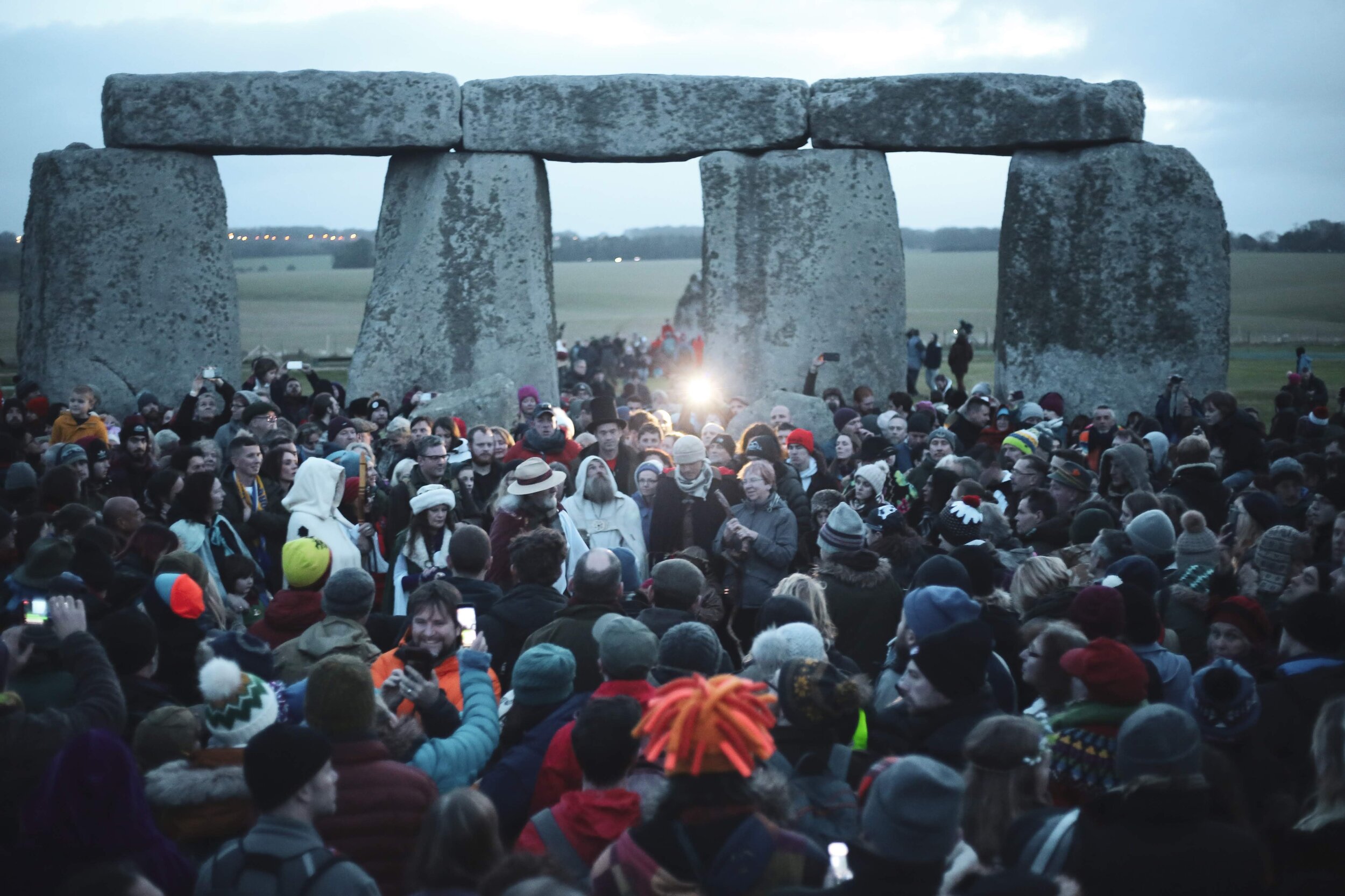
As the 1970s and 80s roll our way, we see Stonehenge being a popular spot for those of an alternative lifestyle. Especially around the solstices, when crowds would appear for the Stonehenge Free Festival, which allowed Festival goers to camp around the site for weeks at a time. But the henge itself was suffering, the anti-social behaviour was not good for it and this wasn’t really in line with ‘protecting’ the site.
Tensions between those coming to Stonehenge for ‘spiritual’ reasons and the authorities finally came to a head in the now infamous Battle of Beanfield in June 1985.
Earlier English Heritage and the National Trust had gone to the High Court and had been given an injunction to prevent the Festival from taking place at all. So naturally police set up roadblocks and exclusion zones in place to prevent people from turning up, barbed wire was even put up around the stones, seems a bit extreme but okay. Then down the road comes the ‘Peace Convoy’ made up of vehicles and about 600 people all heading towards the monument. Naturally they were stopped at the roadblock and pretty much it just devolved from there.
The police said the vehicles were trying the ram the roadblock and the people said the police were violent first. The whole affair went on for a good several hours and in the end some were injured and 537 were arrested. What a fun peaceful day that must have been.
For the next couple of years, similar, but smaller, protests continued as Stonehenge remained closed to the public at the time of the solstice. It actually wasn’t until 2000 that the monument was once again opened up for summer solstice rituals to take place, obviously the whole thing is highly managed, but it seems to be working and still happens today.
It wasn’t until 1983 that the government thought that a whole department was needed for places like Stonehenge, and so the Historic Buildings and Monuments Commission was born. More formally known as English Heritage, it took Stonehenge under its newly formed wing in 1984, when Lord Montagu of Beaulieu was the Chairman.
But Stonehenge wasn’t its only responsibility, it oversaw the care and protection for a whole range of historic places in Britain, and I suppose still does. English Heritage’s main aim is to better these historic sites with guest and tourist facilities, inform and educate those guests and tourists through displays, signs, and of course interpretation.
1986 turned out to be a pretty fun time for Stonehenge and its surrounds. The prehistoric landscapes of Avebury and Stonehenge were formerly added to the UNESCO World Heritage Site list due to their ‘international importance’. The World Heritage Site covers an area spanning 6500 acres, so there’s plenty to talk about there.
While several improvements were made, especially in its landscape, there were also problems that needed serious dealing with. Namely the visitor facilities at Stonehenge just weren’t cutting it and hadn’t been for some time. Not to mention the havoc that cultivation and agriculture was still having on the Stonehenge landscape. And so in 2000 a new management plan was put together that recommended that those parts that were particularly sensitive be returned to natural pasture. Amazingly everyone did their part and between 2003 and 2011, the local farmers were able to restore 25 per cent of the whole World Heritage Site back to grassland. Now that’s what it means to work together. While this work was going on the Stonehenge Environmental Improvements Project got together and were able to provide a new WHS Management Plan in January of 2009, which from what I can gather, is doing pretty bloody well.
Seeing the Stones
When motorways and the railway was added to the English landscape, especially those leading to Salisbury, Stonehenge saw an influx in visitors. Of course we know that originally there was nothing stopping visitors from walking right in amongst the stones, and that when that sarsen fell in 1900 there was serious concern for the safety of those having a little walk about.
As we head into the 1930s we see the number of visitors increase to more than 15 000 stopping by Stonehenge in one month. Admittedly it was a midsummer month, but still, that’s a decent amount of people looking at some rocks. Of course this bump in numbers was attributed to the increase of people owning cars which allowed those people to get out and about for a day or a weekend, and what better place for a day trip than the British countryside? Up until this point, there had only been one single custodian and the poor bloke was getting seriously overwhelmed.
By 1935 cars were blocking traffic as they attempted to enter the area surrounding Stonehenge, so a small car park was added on the opposite side of the road. But this small space wouldn’t really do a whole lot for very long. It was also around this time that the Stonehenge visitor experience was bumped up a level and the site museum that was put in one of the excavation huts used by Hawley and his team. But this spot didn’t really work. The hut had a bad habit of leaking, so the stuff displayed in the museum had to be moved to Salisbury Museum for safe keeping.
Now the Stonehenge Café was a controversial addition. It popped up in 1927 about 360 metres away from the actual stones. Even though it provided a service to the visitors it wasn’t universally liked. Here’s a memo from the Office of Works regarding the café:
[It’s] a cheap flashy little building [which] vulgarises unspeakably this world famous and most impressive monument.
Harsh words for someone just trying to earn a little money. But objections to its presence prevailed in the end with the small building being knocked down in 1938, despite the fact that it was probably exactly what visitors wanted especially in an English winter.
The publicity around the excavations and restorations that took place throughout the 1950s and ‘60s only encouraged more and more to visit the prehistoric monument. And the popularity of programmes like Animal, Vegetable, Mineral, and even Atkinson’s own programme Buried Treasure, only increased the interest around archaeology.
Stonehenge was starting to experience an influx of visitors and attention, and along with those visitors came more cars and more need to cater to those visitor’s needs.
In 1950 the National Trust graciously allowed a mobile tea-bar to set up shop in the carpark, a far cry from the café that had pride of place 18 years earlier. New underground lavatories weren’t added until 1954 and by the time we get to 1960 the car park was finally extended.
But a much larger problem was the havoc thousands of feet were doing to the interior of the stone circle, which basically turned into a bog in winter. Initially the interior was resurfaced with gravel around 1963 in an effort to protect any archaeology that lay underneath. Then the area was managed and harder wearing gravel mixed with bits of concrete was added, which actually helped to level the ground and is what stuck around for the next 20 years. And it’s a good thing this was done when it was, because by the time we get to the 1970s Stonehenge is seeing about half a million people pass on through a year.
In 1966 the car park was once again extended and an underpass was built to provide safe and easy access to the stones. And good thing too, because in the late 60s and early 70s solstice celebrations really started to take off again. In 1974 a ‘Free Stoned Henge Festival’ was promoted and did fairly well with it coinciding with the summer solstice. The next year the crowds were bigger and the tradition lasted for about a decade.
1977 saw a fence introduced which closed off the stones to visitors, you could look at them from afar but not wander among them. The Department of Environment had some serious concerns about the ground erosion that was taking place from all those feet, especially because by the end of the 1970s the numbers were only going one way, and it wasn’t down. The next year, so in 1978, the gravelled area within the circle was removed and returned back to its original grass and a path that moved around the stones was surfaced so that visitors wouldn’t wear out the ground underneath.
In 1993 the Parliamentary Public Accounts Committee took a good hard look at the appalling facilities available to those visiting Stonehenge and labelled them
a national disgrace.
And they were too, not enough toilets and a tiny seating area that masqueraded as a café? Ridiculous. And it took quite a few years for them to figure it out too. It wasn’t until 2013 that the new visitor centre was opened at the edge of the World Heritage Site, so about 2 km from the stones.
The building was designed by an Australian firm, Denton Corker Marshall, and features an undulating roof with thin steel columns, it houses a glass cube where you can find the café and gift shop and a timber box is in there as well containing the museum. Quite a step up from what was there before.
But while the visitor facilities have improved the road situation has not. The idea to widen the road was quickly shut down because it is inside a World Heritage Site, you can’t just go around widening roads wherever you like.
All the way back in 1998, the idea of a tunnel was put forward and pretty much everyone thought it was a pretty good idea. Everyone welcomed it, English Heritage, the National Trust, even all the major archaeological bodies. Plans for the tunnel have even been drawn up. It would be 2.1 km and along with the closure of the A344, which has actually been recommended by UNESCO due to its close proximity to the stones, it would remove roads from the centre of the World Heritage Site altogether. Happy days! But alas, we are now in 2021 and there is still no tunnel. So it’s rather like bullet trains in Australia.
Today, or in a pre-covid world, you can find nearly a million people stopping by Stonehenge every year. It’s much like an icon, not just for our prehistoric past but also for those modern Druid societies that take inspiration and identify with Stonehenge.
The Stonehenge that we see today isn’t complete, but completeness in this sense doesn’t matter, it’s almost all the more loved because it is incomplete and its origins masked behind a veil of history.
There is so much information out there on just these particular stones, forget about the other stone circles that have been found all around the world. If this has piqued your interest do some of your own research, check them out, learn what you can and if you find something interesting definitely let me know, I’d be hella interested to hear about what you find.
Disclosure: As an affiliate marketer, we may receive a commission on products that you purchase through clicking on links within this website.