Machu Picchu
In deepest darkest Peru stands a lost city only known to those living in it.
Only accessible by trekking the Inca Trail, the ‘lost city of the Incas’, as it has become known, stands abandoned atop a mountain. The reason for the absence of human presence is unknown. All that is known is that those pesky Spanish Conquistadors never found it.
Machu Picchu back in the day
One will find the lost city in the High Andes of Peru. Situated within the Machu Picchu Historic Sanctuary and the province of Urubamba, Machu Picchu is only about 75 kilometres from Cusco, once the capital of the Inca Empire.
The Machu Picchu Historic Sanctuary covers 320 square kilometres and is extremely diverse, containing 10% of fauna and 22% of the flora found in Peru, not to mention being home to several endangered species.
The name that the Inca knew the city by has been lost to modern scholars. The name that we know it by today was given by its rediscoverer, Hiram Bingham in 1911. He even said:
The ruins…perched on top of a narrow bridge lying below the peak of Machu Picchu, are called the ruins of Machu Picchu because when we found them no one knew what else to call them. And that name has been accepted and will continue to be used…
We’ll get into the city’s rediscovery a bit later, but the name ‘Machu Picchu’ is a Quechua word, which is an indigenous language of Peru, meaning ‘Old Mountain’.
The city itself is full of cultural significance. It’s just what that significance is, that has eluded historians, archaeologists and scholars alike for centuries. Although archaeological evidence does show that agriculture in some form had been practiced in nearby and the Urubamba valleys since about 760 BC.
While the city and the surrounding area is believed to have had several periods of occupation spanning over 200 hundred years, we do know that the Incas were the ruling elite of this western part of the South American continent. They’re believed to have ruled over more than 20 million people between the 1400s and the 1500s, at one point, the Inca Empire stretched from Ecuador, through Peru and well down into Chile, including parts of Argentina and Bolivia.
The Inca Pachacutec was the Alexander the Great of the South Americas, known as an emperor builder, he made a series of conquests that would see his empire spread. And it was he, that archaeologists and historians agree built the city of Machu Picchu. He ruled over the Tahuantinsuyo, which is the name the Inca gave to their empire, from 1438 to 1471. With radiocarbon dating giving the construction dates of the city within the 15th century, possibly around 1450, which would fit with Pachacutec’s reign.
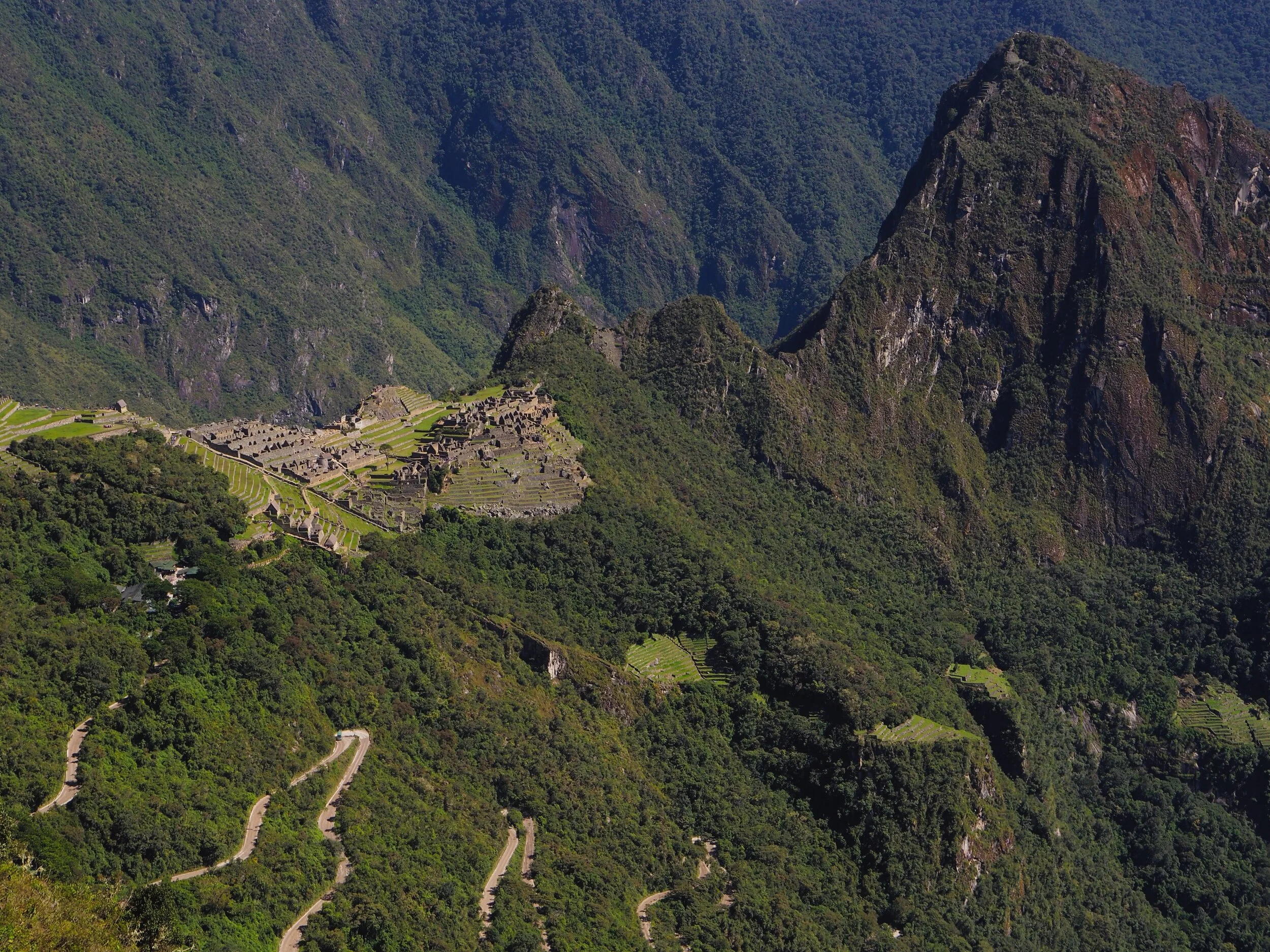
The city of Machu Picchu is built on the slopes of the Villanova mountain range. It’s surrounded by steep cliffs and hidden amongst the surrounding forest. The city is believed to have had only one entrance, and it would have been quite narrow, meaning that like the 300 Spartans at Thermopylae, only a few warriors would have been needed to defend the city if there were to be an attack.
While Cusco developed as a city-state with further conquests by the Incas, the Vilcabamba region came under Incan control around 1440, this is expected to be one of the first in a line of territorial expansions by the empire.
Inca engineering
Even back in the 15th century, the Incas were thinking about preserving the environment. The Inca practice of shaping architecture around the natural terrain in the form of turning ridges into plateaus and slopes into terraces is an excellent example of this. The site that the city stands on is on a, relatively, flat space, between the two peaks of Machu Picchu and Huayna Picchu, it was created by moving large amounts of stone and earth.
What’s of most interest, however, is that the Incas built Machu Picchu and cities like it without knowing of the invention of the wheel or the use of iron tools. Especially since, given the terrain of the high Andes, these wouldn’t have been much help anyway.
The technique used by the Incas is called Idquo ashlar. It’s important to note that not all the buildings and walls were built this way, only the one’s believed to have been used by the royal elite. The technique had no use for mortar between the stones, instead the stones were cut so precisely that they could fit together perfectly. Bingham even remarks in his memoirs after first discovering the city:
The gigantic polygonal blocks cling so closely together that it is impossible to insert the point of a knife between them.
The builders would have chipped and chiselled the rocks from the granite bedrock of the mountain range, and it’s believed that hundreds of men would have then pushed the massive rocks up the mountain. Most of the stones weigh well over 50 tonnes, so without knowing about the ease of the wheel and with steep stairs to navigate. This seems to have been the only way.
The engineering used in these buildings seems also to have been borne out of necessity. Being on the Ring of Fire, the area is incredibly earthquake prone and so having irregular lines where the stones meet would make the buildings and walls almost earthquake proof. This is what National Geographic had to say in one of its articles on the lost city:
Both Lima and Cusco had been levelled by earthquakes, and Machu Picchu was constructed atop two fault lines. When an earthquake occurs, the stones in an Inca building are said to ‘dance’. They bound through the tremors and then fall back into place. Without this building method, many of the best known buildings at Machu Picchu would have collapsed long ago.
South Americans are well known for their agriculture, and the Incas were no different. At Machu Picchu, more than 700 terraces can be found, these would have been used to grow crops for the city and possibly the surrounding valleys. But it also had the added benefit of preventing the city from sliding down the face of the mountain.
Where there’s agriculture, there needs to be a good use of water. And Machu Picchu was no different. By using water from 14 nearby natural springs, the Incas moved the water to where it was needed by cutting channels in the rock and building aqueducts. Producing a water supply system that extended for over a kilometre.
Like many ancient civilisations around the world, architecture was very important for the Incas. With several buildings being built in alignment to possible constellations or solstices. This has been put forward as a possible reason for the construction of the city. But we will get into these possibilities a bit later.
The fall of Machu Picchu
When the Spanish brought an end to the Inca Empire by killing the Inca Emperor in 1533, it’s evident that they never discovered Machu Picchu. And it is for this reason that many think that the city was abandoned by the Inca before the Spanish even arrived.
It was between the years of 1537 and 1545 that the Spanish started to take over what used to be the Inca Empire.
When Machu Picchu was abandoned, it’s believed that the reason the city was lost to memory was because the lower-class citizens of the empire didn’t know about its existence, with only one or two trails leading to the city through tough terrain it’s understandable that the city could go undetected for hundreds of years. This lack of roads leading to the city has given rise to the theory that the reason it was forgotten was because the city wasn’t finished.
It is known that the last of the Incas retreated to the hidden city of Vilcabamba when the Spanish threat became too great. The Spanish conquistadors attempted to look for the city, in an attempt to find whatever treasure had been left behind. But were unsuccessful. Old mate Bingham even has a thought as to how it managed to remain hidden for so long:
The sanctuary was lost for centuries because this ridge is in the most inaccessible corner of the most inaccessible section of the central Andes.
The ‘finding’ of Machu Picchu
The Spanish may have been unsuccessful in finding the city, but the locals had known about it and even lived and worked in the surrounding area of Machu Picchu for hundreds of years.
A couple of explorers before Bingham had even had the good fortune to discover the lost city for themselves. In the late 1800s, explorer Antonio Raimondi crossed the grounds of the Machu Picchu ruins without actually knowing where he was. Augusto Berns managed to form a mining company to exploit the city’s treasures in 1867. And German explorer, Herman Goering, registered the citadel on his expedition map in 1874. But never fear for this Herman, created his map about 10 years before the infamous Hermann of the Nazis was born.
The ruins also got as many visitors through the early 1900s. Enrique Palmas, Gabino Sanchez and Agustin Lizarraga, found and visited the site before Bingham even got close. We know this because their names have been found carved into the ruins of one of the walls in the building called the Temple of the Three Windows. It’s dated 14 July 1901. And even though that cheeky Bingham recorded this inscription in his explorer notes, he conveniently left this out when writing his memoir. The three explorers believed that the ruins were part of an estate. Like farmland in a western country today that is leased out to farmer, when Palma, Sanchez and Lizarraga arrived at Machu Picchu, they found that an indigenous farmer, Anacleto, had been living there and leasing the place out for eight years.
Supposedly it was Lizarraga’s stories of his visits to these fantastical ruins that caught Bingham’s attention and started his journey into the depths of Peru.
It was in 1911, that Hiram Bingham III, a Yale history professor entered the depths of Peru in search for what he thought to be the last place of the Incas retreat, Vilcabamba. The legend says that this city is the last refuge of the Inca where they regrouped in an attempt to hold back the Spanish before they were finally defeated in 1572.
Accompanied by an indigenous speaker from a nearby village, Melchor Arteaga and a sergeant from the Peruvian forces, Bingham trekked for what seemed an age through the forest covering the Andes, during the rainy season, with ridiculous levels of humidity and the ever present threat of jaguars and deadly snakes. When he arrived at the ruins, he had no idea that he was at a ruined city. The jungle had taken over. But he did find the Richarte and Alvarez families farming in the famous terraces to the south of the city. They had been living there for four years by the time Bingham found them. At noon on the 23 July 1911, it was a small boy from one of these families that took Bingham to the top of the ruins and showed him around the ‘urban area’ of the city which was completely covered by jungle at the time.
Bingham’s initial thought was that he had found the refuge of the Incas, Vilcabamba, and remained convinced of this, despite the evidence. Strong in the belief that he had found the traces of
the largest and most important ruin discovered in South America since the days of the Spanish conquest.
It wasn’t until after his death in the 1950s, that the real Vilcabamba was discovered further west. Despite this more recent discovery, the title of the ‘lost city of the Incas’ has remained with Machu Picchu.
Throughout 1912 and 1915, there were several excavations of the site. The overgrowth was cleared from the ruins and Inca tombs were excavated. There was a fair bit of pottery found, but because of the climate being so humid, almost no clothing or fabric would be salvaged. Of the excavated graves, over 100 burial caves were found within the ruins. It was under Dr George Eaton that the archaeologists recovered and studied 164 human skeletons. At the time it was believed that a disproportionately high number of these skeletons were female. Leading Bingham to suggest that the city had been built as a sanctuary for the Virgins of the Sun, of which there were several throughout the Empire. Bingham notes in his book:
These Chosen Women, whose lives were consecrated to the service of the sun, his representative, the Incas, and his priests, lived in sanctuaries which were scattered throughout the Inca Empire.
However, it should be noted that in recent years, new technology and methods of determining sex and age of skeletal remains has put into doubt the original findings, and some experts having even reclassified a significant proportion of the remains as males.
Of the numerous artefacts found at Machu Picchu, they were all flown back to North America, to be housed in Yale’s Peabody Museum, where they were inventoried and put into storage.
There were several further excavations throughout the 1930s, 40s and 50s. Although none of these excavations could confirm the reason for Machu Picchu, only theories.
Myths of reasons
Scholars, historians and archaeologists are still trying to figure out what Machu Picchu was used for. And there have been several theories along the way suggesting possible usages of the hidden city. The major issue is that there are no records left behind by the Inca, as National Geographic so succinctly put
the Inca had no written language, so they left no record of why they built the site or how it was used before it was abandoned in the early 16th century.
You can find an exhaustive list of the possible reasons for the city if you search the interwebs. It’s been put forward that it was used as a fortress or military stronghold, imperial retreat, ceremonial precinct, place of pilgrimage. And some even more outlandish ones, such as it really is the last city of the Inca, Vilcabamba, which we know to be incorrect, or that the ruins predated the Inca, and that they never knew about the city themselves.
Although the types of buildings thought to have been found can be used to somewhat narrow down the list. National Geographic again;
The complex of palaces and plazas, temples and homes may have been built as a ceremonial site, a military stronghold, or a retreat for ruling elites.
The theory of a ceremonial site is supported by the Italian archaeoastronomer Giulio Magli, now that’s a fancy job title if ever I heard one. Magli reckons that the journey from Cusco to Machu Picchu could have been one of ceremonial purpose. Like many similar ancient ruins, there are parts of the city that seem to aid in astronomical observation. Think Stonehenge.
Another suggestion, supported by the findings of the human remains, was that the city was a refuge for the Virgins of the Sun or Ñustas. The thinking is that they were sent to Machu Picchu to wait out the Spanish invasion. And to continue their worship to the Sun God, potentially hoping for a favour from the deity over the invading Spanish.
One of the most common theories, is that the city was built for the Inca King Pachacutec, as a royal estate. And potentially as a reminder to the recently conquered local population of the might of the Inca Empire. As a refuge for the elite members of the Inca, Machu Picchu could have been a sacred centre of political, religious and economic thought. Because we always need one of these in the middle of the jungle.
It’s believed that the city could only manage to house 1000-2000 people, which could have been made up of members of the Inca royal family, religious elite, and the others that make up a royal household.
Parts of Machu Picchu
The level of preservation of Machu Picchu is remarkable and a testament to Inca engineering, considering it had sat forgotten for centuries. The city is surround on the southern, eastern and western sides by stepped agricultural terraces and aqueduct systems. Although we already know, some of these terraces were still being used by indigenous Peruvians when Bingham stumbled upon them in 1911. The city also contains thousands of steps, made from stone blocks or footholds carved into the underlying rock. These stairways connect the plazas, residential areas, terraces and other major parts of the site.
It’s believed that each structure had a specific function, and while many of the buildings have been given names for what is believed to have been their purpose, it is still just guesswork of the limited amount of evidence that is available.
The city is split into two main sectors and divided into lower and upper parts. A large square appears to separate the farming from the residential areas. Even back in ancient Peru they knew a good work-life balance when they saw one. The agricultural sector can be found in the south, with rows of terraces and large store houses. The urban sector is the upper section in the north. Here streets, storehouses, lodgings and even temples can be seen.
Even though the city has a wall, a gateway and even a moat, most likely for collecting rainwater, it doesn’t look like a military stronghold was the main idea behind it. The unique layout of Machu Picchu does suggest an urban design. Precincts, plazas, temples, tombs, canals, stairways and platforms are distributed throughout the cleared mountain area in a way that suggests this urban design is most likely. Made by building a stone wall and filling it with material of different layers, the more than 700 terraces would have promoted agriculture along with the extensive water distribution system and use of terraces to prevent soil erosion. Warehouses, presumably for the storing of crops and grain, can also be seen on some of the terrace platforms. UNESCO even reckons
numerous subsidiary centres, an extensive road and trail system, irrigation canals and agricultural terraces bear witness to longstanding, often on-going human use.
The living area of the city is separated from the agricultural section by a wall that’s roughly 400 metres long. This is where the occupants would have lived and completed most of their civic and religious activities.
Machu Picchu today
When Bingham wrote a book about his adventures to Machu Picchu, titled The Lost City of the Incas, he started what has become a mecca of tourists, that have been flocking to the site ever since. But you might be asking why is Bingham given the credit of finding Machu Picchu when it’s clear that other explorers got there first? And that, my friend, would be a really really good question. But the answer is pretty simple. He quite literally wrote the book. He was louder than the other explorers about his discovery. Not to mention that the local farmers and people in the nearby villages all knew about the ruins, even if they didn’t know about the purpose or significance of the city. And that is why it’s been said that Binghim ‘rediscovered’ the city.
Since Bingham visited, Machu Picchu has become Peru’s most visited tourist attraction and South America’s most famous ruins. And South America has a lot of famous ruins. The 1980s was big for Machu Picchu. In 1981, Peru created the Historical Sanctuary that now encompasses the site, and in 1983 the site was included as a UNESCO World Heritage Site. Then a little more recently, in 2007, it was named as one of the New Seven Wonders of the World, which was chosen through an online survey put on by the Swiss company, the New 7 Wonders Foundation. Tens of millions of people voted in the survey which are all UNESCO World Heritage sites. Machu Picchu sits in pretty good company though, alongside The Great Wall of China, The Taj Mahal, Petra, the Colosseum, Christ the Redeemer and Chichén Itzá.
In 2011, the centennial of Bingham’s ‘scientific discovery’ of Machu Picchu brought a renewed interest in the site from tourists who had travelled abroad. As well as sparking the controversy over the rightful possession and guardianship of the ancient artefacts and remains removed by Bingham’s archaeological excavations. After a little more than several years of pressure from Peru, Yale finally agreed to return the artefacts to Peru. A new museum and research centre has even been created in Peru to house the artefacts. If you find yourself in the area, you can now see the returned artefacts on display at La Casca Concha in Cusco.
2013’s official tourism figures showed that 650 000 visitors had seen the ruins of Machu Picchu, with those number peaking during the months of June and July. Because of the increase in tourist numbers, the Peruvian Government has taken steps to protect the ruins and prevent erosion due to over tourism. With the site under the protection of the National System of Protected Natural Areas of the State, or SERNAP, Machu Picchu now has a limit of visitors per day.
In an attempt to reduce the environmental impact and exploitation by tourism, there is a current limit of just 2500 entrance tickets per day. Despite this limit, the demand to visit the city is growing by about 10% each year. While only 400 people are allowed to climb the second, slightly smaller, mountain of Huayna Picchu each day, you can still climb the bigger, Machu Picchu mountain. Although be warned, it is almost twice as tall at 1640 feet.
If you are planning a visit in the near future, there are several ways that you can arrive at the ruins of Machu Picchu. One is you take a train, there’s one that’s 4 hours from Cusco, or 2 hours from the Sacred Valley. It can be a bit pricey though, with tickets sometimes more than $100, not including the entrance fee to the site. There is also a bus that can take you up and down the mountain.
If you’re a bit of an explorer yourself, you can always follow in Bingham’s footsteps and take on the classic Inca Trail, or Caminos Del Inca. This trek originally took Bingham six days, but could take you as little as 3, and it goes right up to the Sun Gate entrance. Unfortunately it’s no longer possible to do the trek by yourself. Because of heavy use the trail is now heavily regulated, so you will need to sign up with an organised group. But get in early, there can be a bit of a waiting list. And take your shoes that are used for walking, because the trail is tough. It traverses a wide range of elevations, anywhere between 2600 and 4200 metres. It’s also lined with Inca ruins, stone-cut steps, high retaining walls, tunnels and other feats of classical Inca engineering.
If you want a bit of everything but don’t like the idea of walking for days. There is a day trip from Cusco. The first bit is by train, then a 500 metre walk from the Urubamba River valley along a serpentine road. You’ll need your shoes that are used for walking for this one too, because it’s a steep path and roughly follows Bingham’s 1911 route, featuring extraordinary views that are even mentioned in his book.
Something not commonly known to many visitors is that Machu Picchu has it’s very own museum. The Museo de Sitio Manuel Chávez Ballón has all the info you might need. It’s inconveniently tucked at the end of a long dirt road near the base of the city, so it’s easy to miss. It’s about a 30 minute walk from the town of Aguas Calientes. You might want to stop by this little town, because it’s got a hotel with a restaurant, and even thermal baths.
So if you’re in the area, definitely check it out, take amazing pictures and just watch out for those pesky Spanish Conquistadors.


For those in the UK - click here
-
What happens to Machu Picchu when the tourists disappear? - SBS
Trekking to Machu Picchu has never been easier - Forbes
Peru to plant one million trees around Machu Picchu - The Jakarta Post
Armchair Travel: Adventure in Machu Picchu - Travel Pulse
New international airport for Machu Picchu sparks outrage - The Guardian
Londoner sets off on four-day Machu Picchu trek - Metro
Machu Picchu was hit by strong earthquakes during construction - Science Mag
Ancient Incan sanctuary intentionally built on faults - Science Daily
-
Machu Picchu facts - MachuPicchu.org
A bite-sized history of Machu Picchu - Intrepid Travel
Machu Picchu - National Geographic
Historic Sanctuary of Machu Picchu - UNESCO
Machu Picchu 101 - National Geographic
Machu Picchu - Ancient History Encyclopedia
Discover 10 secrets of Machu Picchu - National Geographic
Machu Picchu: Facts and History - LiveScience
The New Seven Wonders of the World - The New York Times
Yale agrees to return Machu Picchu artefacts to Peru - Science Mag


Disclosure: As an affiliate marketer, we may receive a commission on products that you purchase through clicking on links within this website.